The GIS world is in anticipation of the arrival of ArcGIS 10. The new version of ESRI’s GIS suite has been discussed as the largest revision since the premiere of ArcGIS 8. The City of Brea has signed up for the unreleased ArcGIS 10 BETA program to get accustomed to these major changes. Here are a few of the new features we have had the opportunity to discover in our first weeks with the Pre-Release of ArcMap 10.
The editing functions in ArcMap 10 have changed significantly. Before, there was always a risk of damage and change to other GIS layers while working on another simultaneously. The major predicament was the selection of multiple layers. A selection checkbox window was available to choose data layers that could be worked on. New functions allow for a single step to ensure there is only one selectable layer.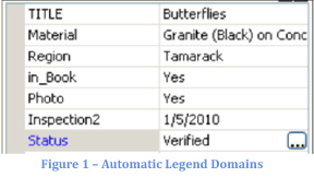
Input of attributes is easier, as now there are automatic field domains. This is available when a map legend is specified on the table of contents. In Figure 1, the Status field input for this point feature can be updated by clicking the Choose Symbol Class (...) button. Another window appears showing the various domain choices given according to the table of contents and symbology. Also, as part of this functionality, date fields have been updated and are easier to use. The calendar in Figure 2 operates more smoothly in ArcMap 10. Typing entries has become a bit less tedious. The field change can sometimes be just a point and click. Another small selection feature is the selection lasso (Fig. 3) which can speed up specific selection interests by tracing a line 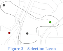 around the desired items.
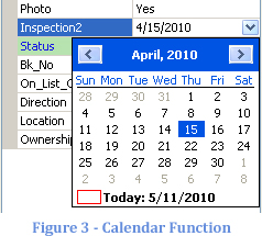
Changes and advances are always going to impact the information technology industry. GIS is about to benefit from these newest ideas. There are many more changes in ArcMap 10. While these are but a few, more will be discussed in the future to help improve your workload.